 Fall Project Report 2015
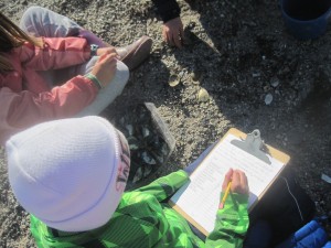
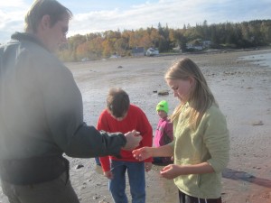
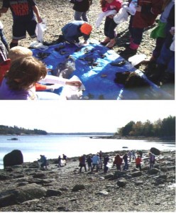
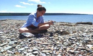
This year seven sixth through eighth grade classes from the Deer Isle School, Penobscot, the Adams School, Blue Hill Consolidated, and Surry received class visits from program manager Jon Monroe and collected hundreds of data points for the Shore Inventory. The kids were attentive, eager to help, and ready to ask very good questions about the future of one of Maine’s most important aquatic species, the softshell “steamer” clam..
They collected and sorted shellfish species…They filled out data sheets… and they asked questions…
Now that the weather is turning cold we look forward to providing these young scientists with some feedback about their work and the cause that they and their teachers have generously supported with their time and energy.
Special thanks to:
Bill McWeeny (Adams School)
Sarah Dunbar (Surry School)
Laura Johns (Surry School)
Chandra Bisberg (Penobscot School)
Martha Bell (Island Heritage Trust)
Mickie Flores (Deer Isle School)
Jason Allhouse (Deer Isle School)
Nell Herrmann (Blue Hill Consolidated)
Pictures for this post are from the Adams School class trip to the Back Shore Road site in Castine on October 23, 2015..
New Shore Project Manager
Jon Monroe has signed on as the new project manager for our Shore Project. Though he does not have a scientific background, he comes to this project with great enthusiasm for involvement with “citizen science”. To date he has visited area schools to introduce himself to teachers and set up field trips for the project.
Fall Report from Martha Bell
Friends of Blue Hill Bay’s Shore Inventory Project 2014
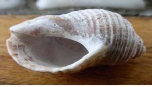
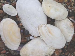
During 2014 Friends of Blue Hill Bay undertook a shore survey of clam flats in Blue Hill Bay. More than 100 participants became citizen scientist as they identified organisms with field guides and counted a variety of species in carefully measured plots along the shores of Blue Hill Bay. Species counted included soft shell clam, blue mussel, common periwinkle, dog winkle, surf clams, green sea urchin, green crab, hermit crabs, razor clam and amphipods.
Once species were tallied on data sheets, participants had a good idea what lived at their clam flat site. It was now time for phase 2 of their shore inventory study, but some background knowledge needed to be shared. Students were asked to think about climate change and ocean acidification. Hands on experiments and visual demonstrations enabled students to see how the addition of CO2 (carbon dioxide) can change sea water or how shells made of calcium carbonate thin or dissolve with the addition of acidic solutions. Scientific research projects were referenced and discussions continued. What might this mean for Blue Hill Bay? Change in species diversity or thinning of clam shells were often answers from the young scientists.
Students continued their work by gathering baseline data on the shell thickness of soft shell clams within their plots. Rulers and digital calipers were used to measure width, length and shell thickness at the clam midpoint. Data was recorded. Might we see change over time? We now have the data gathered by many dedicated citizen scientist in 2014 that we can reference in the future.
Funding for this project was made possible from for Maine Community Foundation and the John Sage Foundation.
———————————————————————————————-
Cemetery Beach, Blue Hill – BHCS 8th grade
Curtis Cove, Blue Hill -Bay School 8th grade
Surry Town Landing, Surry- Surry school grade 6-8th
Naskeag Point, Brooklin- Brooklin School grade 6-8
Oceanville Bridge shore, Stonington– Deer Isle Stonington High School
Tennis Preserve, Deer Isle- Island Heritage Trust Interns
Atlantic Boat Yard shoreline- Brooklin- Downeast Audubon members
South Blue Hill Wharf Beach, Blue Hill- After School Science Club
Taking a look at intertidal ecosystems in our own backyard
We launched the Shore Inventory Project in 2013 thanks to sponsorship from the Maine Community Foundation and the John Sage Foundation. Thank you!
What We’re Doing
Shore Inventory Project
Children and adult volunteers can come to the shore and collect data that will help us understand change due to climate, sea level rise, and acidification. We are excited about this new Project! Join us in helping people increase their appreciation for marine ecosystems through hands-on involvement in citizen science.
Friends of Blue Hill Bay hired high school student Allie Hayes as a summer intern for the Shore Inventory Project in 2013. Thank you to Allie for designing this brochure. She had help from Barbara Arter and Dr. Alison C. Dibble.
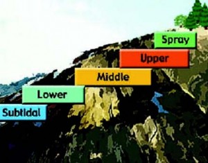
Intertidal Zones
The shore has been divided into zones with characteristic organisms in each zone.
•The Spray Zone gets some splash from waves, and is habitat for lichens
•The Upper Intertidal Zone is submerged during high tide, habitat for blue-green algae
•The Mid Intertidal Zone is often submerged, habitat for barnacles
•The Lower Intertidal Zone is exposed at low tide, habitat for brown algae and blue mus-sels
•The Subtidal Zone is always underwater, habitat for kelp.
Maine’s Big Tides
The northern Atlantic coast features some of the largest tides in the world, with a large intertidal area. The Maine coast has two high tides and two low tides every day, with low tide at 6 hours after high tide. The tide range (the distance between the high tide and low tide mark) in Blue Hill Bay averages 10 feet.
What does it mean?
Living in the intertidal zone means that the ocean does much of your work for you every time the tide comes in. For example, passing waves push new water into filter feeders such as blue mussels, bringing food with it, while pushing old water out. They can filter nutrients out of the water and grow.
However, life in the intertidal zones is not easy. During low tide, organisms are baked by the sun or frozen in winter winds. At high tide they are immersed in cold water and may be buffeted by strong waves. Animals that endure such changes are specially adapted to these extremes. They prey upon each other, and clean up after one another in an intricate and rich ecosystem. Some eat only algae, while others eat — each other!
What’s Happening?
CO2 emissions from factories, vehicles, etc., have led to increasing acidity in ocean water. This alters the habitats for many ocean-dwelling organisms. Their life cycles could be negatively affected, with increasing difficultly for some species to survive.
Clams may be vulnerable
Marine mollusks require a specific water chemistry to grow their shells. Free-floating larvae cannot settle in acidic mud. Bivalves such as the soft shelled clam, a major economic species in Maine, could suffer.
Care to support the Shore Inventory Project?
NEPTUNE $1000 — send a group of school children and their teachers to the shore; pre- and post- field trip activities in classroom
SAND DOLLAR $500 — help sponsor a school field trip or public presentation by our coordinator
PERIWINKLE $100 — help get kids out on the shore, collecting useful data and developing a lifelong interest in the marine sciences
Please contact Bebe Moulton, info@fobhb.org or contribute through our web page: www.fobhb.org